Administered by:

#spatial


Faszinierende Visualisierung von Schiffs- und Flugrouten / Fascinating visualization of ship and flight routes https://geoobserver.de/2025/08/15/faszinierende-visualisierung-von-schiffs-und-flugrouten/ via @PythonMaps #gistribe #gischat #fossgis #foss4g #OSGeo #spatial #geospatial #DataViz #gis #geo #geoObserver pls RT


FOSSGIS 2027: Call of Location! https://geoobserver.de/2025/08/08/fossgis-2027-call-of-location/ #fossgis #fossgis2027 #gistribe #gischat #foss4g #OSGeo #spatial #geospatial #opensource #DataViz #opendata #osm #openstreetmap #gis #geo #geoObserver pls RT @FOSSGIS_Konf


Geoviz 8.0.1 
There is now an `earth` layer type that allows you to add NaturalEarth basemaps to make the maps look nicer. And you can now export the maps in svg (with organized layers) for publishing cartography. See https://github.com/riatelab/geoviz #JavaScript #Spatial #Cartography #Maps
42! Happy Birthday GRASS! https://geoobserver.de/2025/07/30/42-happy-birthday-grass/ #grass #grassgis @grassgis #qgis #switch2qgis #gistribe #gischat #fossgis #foss4g #OSGeo #spatial #geospatial #opensource #gis #geo #geoObserver pls RT

#spatial #programming #commonLisp #leonardoCalculus
https://screwlisp.small-web.org/lispgames/LCKR-organisms-2/
New organisms-2 knowledgebase,starting out with local spatial walking at @mdhughes https://mdhughes.tech/ recommendation that fast access to local neighbors is fundamental.
I.e. I don't want to check every organism in the world to check who is standing next to me. Well, I put that in a knowledgebase in my organisms-2 #KRF here.
Seems to work, pulls in 8 connected and 24 connected neighbors rightly.
BfN: Daten zu Flussauen / Data on floodplains https://geoobserver.de/2025/07/24/bfn-daten-zu-flussauen/ #naturschutz #flussauen #gistribe #gischat #fossgis #foss4g #OSGeo #spatial #geospatial #gis #geo #geoObserver pls RT via @BfN_de

Work for the Smithsonian!
--
https://trustcareers.si.edu/en/postings/560a4d08-11ef-45a3-a8bf-cc550f70c8fd
--
#GIS #spatial #mapping #twoyearfixed #smithsonian #job #jobopening

FOSSGIS 2026: Konferenzseite ist Online / Conference page is online https://geoobserver.de/2025/07/16/fossgis-2026-konferenzseite-ist-online/ #fossgis #fossgis2026 #gistribe #gischat #foss4g #OSGeo #spatial #geospatial #opensource #gis #geo #geoObserver pls RT
GDAL Released: v3.11.3 https://geoobserver.de/2025/07/15/gdal-released-v3-11-3/ via @GdalOrg @EvenRouault #gdal #ogr #qgis #switch2qgis #fossgis #foss4g #opensource #gistribe #gischat #spatial #geospatial #gis #geo #geoObserver pls RT
GIS-Wissen: Dateiformate in GI-Systemen / GIS knowledge: File formats in GI systems via @MashfordMahute https://geoobserver.de/2025/07/11/gis-wissen-dateiformate-in-gi-systemen/ #gistribe #gischat #fossgis #foss4g #OSGeo #spatial #geospatial #gis #geo #geoObserver pls RT
Mieux.
Non seulement les journalistes n'ont pas gratté ce qu'il y avait derrière les beaux discours, mais en plus le bonhomme a été bombardé "spécialiste" et invité à ce titre à commenter certains événements.
Une fusée explose ? Invitons donc le spécialiste du tourisme #spatial pour commenter !
8/
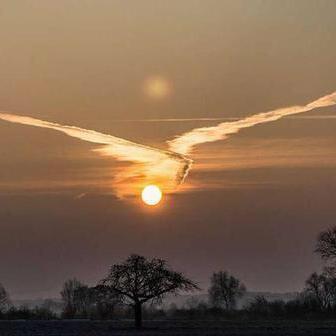
#Photographie #Spatial #Météo #Orages
photo prise depuis l'ISS
par la spationaute Nichole Ayers (NASA)
Un farfadet lors d'un orage au-dessus du Mexique ce jeudi. Comme un éclair, mais rouge et au-dessus des nuages.
https://fr.wikipedia.org/wiki/Ph%C3%A9nom%C3%A8ne_lumineux_transitoire
 :
:
https://www.instagram.com/astro_ayers/p/DLpwscZRshj/
ou
https://xcancel.com/Astro_Ayers/status/1940810789830451563
Hurricane Science Was Great While It Lasted
The U.S. is hacking away at support for state-of-the-art forecasting.
--
https://www.theatlantic.com/science/archive/2025/07/hurricane-science-noaa-cuts/683398/ <-- shared media article
--
https://www.ncei.noaa.gov/access/metadata/landing-page/bin/iso?id=gov.noaa.ncdc:C00797 <-- shared NOAA SSMIS page
--
https://www.earthdata.nasa.gov/data/instruments/ssmis <-- shared NASA SSMIS home page
--
#GIS #spatial #mapping #remotesensing #fedopendata #earthobservation #model #modeling #fedscience #fedservice #hurricane #imaging #SSMIS #spatialanalysis #spatiotemporal #weather #climate #climatechange #extremeweather #NationalHurricaneCenter #stateoftheart #forecasting #hurricaneseason #risk #hazard #mitigation #planning #management #NWS #loss #cost #economics
@NOAA @nasa
A Global Map Of Travel Time To Access Veterinarians
--
https://doi.org/10.1038/s41467-025-60102-y <-- shared paper
--
#GIS #spatial #mapping #spatialanalysis #global #vet #Veterinary #Veterinarian #healthcare #food #animal #foodsecurity #subsistence #geography #healthcareaccess #access #model #modeling #income #economics #cost #savings #mitigation #resources #resourceallocation #disease #surveillance
Forests And Cycles Of Agrarian Sustenance - Time-To-Event Analysis Of Ecosystem Provisioning Services And Seasonal Food Insecurity [Sub-Saharan Africa]
--
https://doi.org/10.1080/26395916.2025.2484490 <-- shared paper
--
#GIS #spatial #mapping #Ghana #MoleNationalPark #Larabanga #Kananto #Kabampe #Grupe #Jang #ecosystem #savanna #Africa #SubSaharanAfrica #food #farming #agriculture #foodsecurity #water #hydrology #weather #climate #watersecurity #rainfall #precipitation #forest #Agrarian #services #seasonal #foodinsecurity #risk #hazard #vegetation #rights #humanrights #forestmanagement #commonland #enclosures #agronomic #stewardship #spatiotemporal #spatialanalysis #income #cost #economics #planning #policy #governance #community