Chapter 9: Mapping & Visualization 


Introduces tools for making static, animated, and interactive maps in R. Covers the tmap package and web-based options for sharing geographic data visually.


Chapter 9: Mapping & Visualization
Introduces tools for making static, animated, and interactive maps in R. Covers the tmap package and web-based options for sharing geographic data visually.
From Brittany Barker: ‘My "GIS and Mapping in R" workshop for the Cascadia R Conference . . . is available at GitHub and includes four exercises that focus on using "sf", "terra", "ggplot2", and "leaflet" for geospatial analyses and creating static and interactive maps’
#RStats #RSpatial
(Barker is an asst research professor at Oregon State University in Portland)
https://github.com/bbarker505/CASCADIA_R_Intro_to_GIS_2025

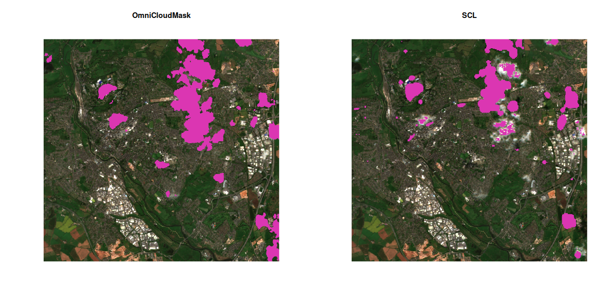
Ooh CNN-based cloud masking baked right into a VRT file. This should be fun! #rstats #rspatial #gdal #python
This is using https://github.com/DPIRD-DMA/OmniCloudMask and appears to be a massive improvement on the standard Sentinel 2A SCL band!
@MichaelTBacon @eliocamp here it seems #Rspatial is innocent, #GDAL error is helpful here.
I should start collecting all the ways in which #RSpatial can go wrong spectacularly.
 :
GDAL Error 1: PROJ: proj_create_from_database: /g/data/hh5/public/apps/miniconda3/envs/analysis3-24.04/share/proj/proj.db contains DATABASE.LAYOUT.VERSION.MINOR = 2 whereas a number >= 5 is expected. It comes from another PROJ installation.
Error: crs not found: is it missing?")
Chapter 8: Geographic Data I/O 


Covers how to read and write spatial data in various formats, access open geoportals, and work with geographic web services in R. Includes tips on metadata and exporting maps.


 I gave a talk on measuring spatial autocorrelation in spatial machine learning at the #AGILE0GI conference.
Slides: https://jakubnowosad.com/agile-gi2025/
Always glad to discuss spatial ML or autocorrelation --- feel free to reach out!


I just posted a new short blog article! 
It's about using layer functions with {terra} in R — a handy way to work with multi-layer rasters without making your code a mess. It shows how to apply functions to raster layers.
https://www.pmassicotte.com/posts/2025-06-12-terra-layer-funs/

Spatial prediction meets machine learning with mlr3 
This blog post by Marvin Ludwig also includes tips on autocorrelation, extrapolation & more.
Chapter 7: Coordinate Reference Systems 


This chapter explains how to work with coordinate reference systems (CRSs) in R. Learn how to reproject vector and raster data, and understand how CRS choices affect spatial analysis.


Rainy day here, so I'm using #GenerativeAI to help teach me more about Kyle Walker's cool {mapgl} #RStats . And it's been pretty fun so far.
1) I uploaded mapgl help files and vignettes to both ChatGPT & Claude.
2) I used the CustomGPT AI Tutor Blueprint https://chatgpt.com/g/g-1rlItjngn-ai-tutor-blueprint to create a good prompt for a mapGL tutor.
3) I added that prompt to Claude, and my tutor was ready!
Prompt: https://gist.github.com/smach/4c08c4d93836f0b63c17a5f1b077dac9
The {pkgprompt} and {rdocdump} #R s help turn R docs into text.

Add data as \"sources\" - your sf objects become data sources
Add \"layers\" that reference those sources - these are like geoms but work differently
Style with expressions - not aesthetics, but JavaScript-style expressions
This is more like how a web developer builds an interactive map, which is why it's so powerful for complex visualizations.
Before I show you the syntax, let me test your intuition: If you had to guess, how do you think you'd start building a mapgl map differently than a ggplot? What do you think comes first - the data or something else?
And here's a follow-up: Given that mapgl creates interactive web maps, what do you think might be the equivalent of choosing your x and y variables in ggplot2?")
Hey #RStats / #RSpatial friends, I'm experiencing this weird bug, I've reported it to sf but Edzer can't reproduce. Anyone else seeing the same? Pretty simple steps if you want to try it out and confirm.
https://github.com/r-spatial/sf/issues/2526
, sf errors in subset2. If the same dplyr code is run one more (which should not create a different object at all??...")
Exciting news!  The 2nd edition of Geocomputation with R is now available as a physical book!
Order your copy today and explore the latest in R for spatial analysis.
Learn more about the book's journey: https://buff.ly/3TZzc4L

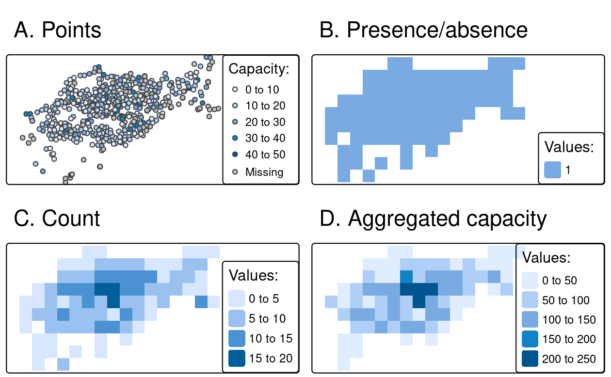
Chapter 6: Raster-Vector Interactions 
Crop, mask, extract, and rasterize!  Learn how to convert between raster & vector data and perform spatial extractions in R.

 Quick trick: subsetting the BIOCLIM CHELSA dataset by the Swiss Federal Institute for Forest, Snow and Landscape Research WSL using Cloud Optimized Geotiff (COG) functionality in R.
This feature seems overlooked in the documentation but could save you orders of magnitude in time, bandwidth and disk space - depending on the use case.
https://bluegreenlabs.org/post/chelsa-cog-geotiff-subsetting/

New blog post: Spatial Machine Learning with tidymodels 
This post shows how to apply the tidymodels framework to spatial data workflows in R. Part 3 in a series about #sml.


For the win. When you discover that a dataset is (accidentally?) formatted as COG Geotiffs, and saves you hundreds of GB in downloads.
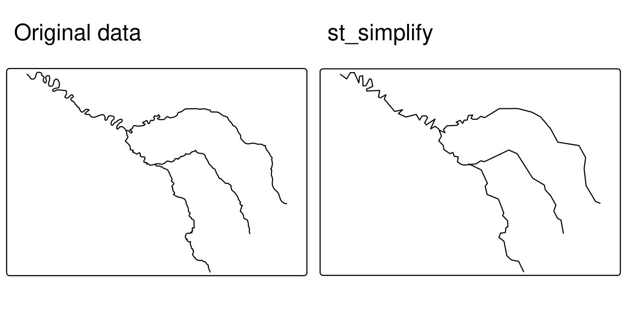
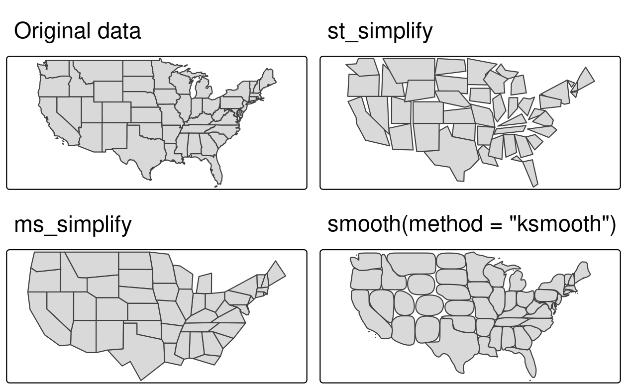
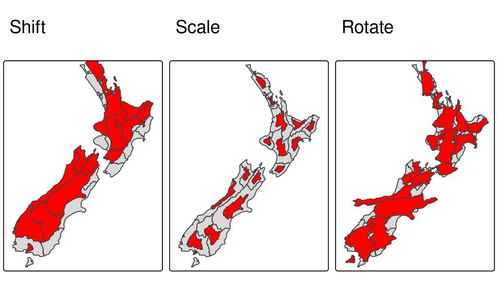
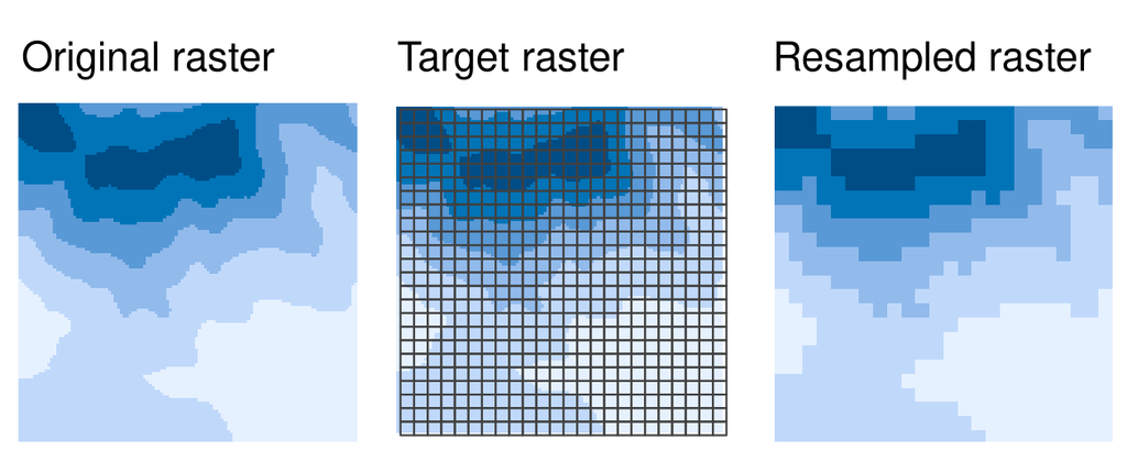
Chapter 5: Geometry Operations 
Simplify, buffer, transform! Learn to modify vector geometries, clip spatial data, apply affine transformations, and resample rasters for better alignment.