Recent searches
Search options
#arwx
@nwsspc_bot #SevereWeather #ARwx
URGENT - IMMEDIATE BROADCAST REQUESTED
Tornado Watch Number 199
NWS Storm Prediction Center Norman OK
325 PM CDT Wed Apr 30 2025
The NWS Storm Prediction Center has issued a
* Tornado Watch for portions of
Central Arkansas
* Effective this Wednesday afternoon and evening from 325 PM
until 1000 PM CDT.
* Primary threats include...
A couple tornadoes possible
Scattered damaging wind gusts to 70 mph possible
Isolated large hail events to 1.5 inches in diameter possible
SUMMARY...A line of strong/severe thunderstorms over western
Arkansas will progress eastward through the late afternoon and
evening. Locally damaging wind gusts and a few tornadoes will be
possible with this activity.
The tornado watch area is approximately along and 70 statute miles
east and west of a line from 50 miles northeast of Russellville AR
to 40 miles west southwest of Monticello AR. For a complete
depiction of the watch see the associated watch outline update
(WOUS64 KWNS WOU9).
#SevereWeather #ARwx #LAwx #TXwx
URGENT - IMMEDIATE BROADCAST REQUESTED
Tornado Watch Number 198
NWS Storm Prediction Center Norman OK
105 PM CDT Wed Apr 30 2025
The NWS Storm Prediction Center has issued a
* Tornado Watch for portions of
Southwest Arkansas
Northwest Louisiana
East Central Texas
* Effective this Wednesday afternoon and evening from 105 PM
until 800 PM CDT.
* Primary threats include...
A few tornadoes likely with a couple intense tornadoes possible
Scattered damaging wind gusts to 70 mph likely
Scattered large hail and isolated very large hail events to 2
inches in diameter possible
SUMMARY...Thunderstorms are expected to rapidly develop across the
watch area through the afternoon. Sufficient vertical shear and
instability will pose a risk for a few tornadoes, along with large
hail and damaging wind gusts.
The tornado watch area is approximately along and 70 statute miles
north and south of a line from 40 miles south southwest of Waco TX
to 50 miles east of Shreveport LA. For a complete depiction of the
watch see the associated watch outline update (WOUS64 KWNS WOU8).
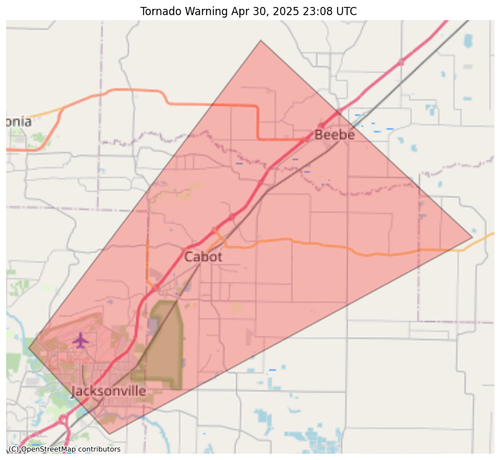
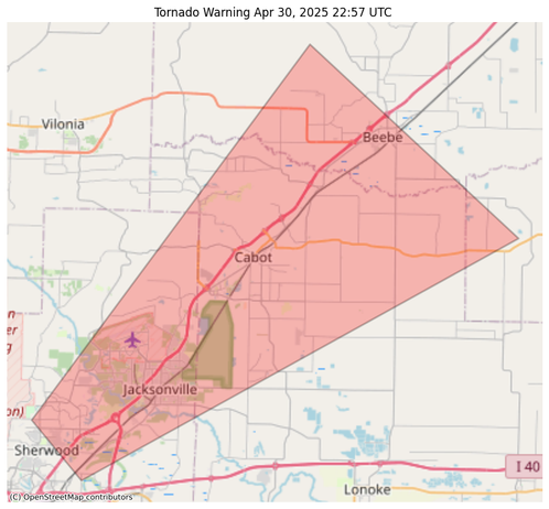
#NWS #tornado Tornado Warning for Lonoke, AR; Prairie, AR; Pulaski, AR; White, AR #ARwx https://alerts-v2.weather.gov/search?id=urn:oid:2.49.0.1.840.0.029c1e0877dc3dc2315eaf0e7227abac4555718a.001.1
#NWS #tornado Tornado Warning for Lonoke, AR; Prairie, AR; Pulaski, AR; White, AR #ARwx https://alerts-v2.weather.gov/search?id=urn:oid:2.49.0.1.840.0.33f76d27c1a2237e8bc23b03615fd661c1f5d259.001.1
@easwatch #SevereWeather #ARwx #EAS #WEA for Lonoke, #AR; #Prairie, #AR; #Pulaski, #AR; #White, #AR: National Weather Service: #TORNADO WARNING in this area until 6:45 PM CDT. Take shelter now in a basement or an interior room on the lowest floor of a sturdy building. If you are outdoors, in a mobile home, or in a vehicle, move to the closest substantial shelter and protect yourself from flying debris. Check media. Source: NWS Little Rock AR ** DO NOT RELY ON THIS FEED FOR LIFE SAFETY, SEEK OUT OFFICIAL SOURCES ***
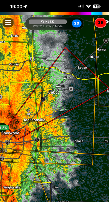
7:00 pm EDT Radar KLZK Little Rock showing radar indicated tornado. Signature is obscured by closeness to the radar.
Image Radar Omega
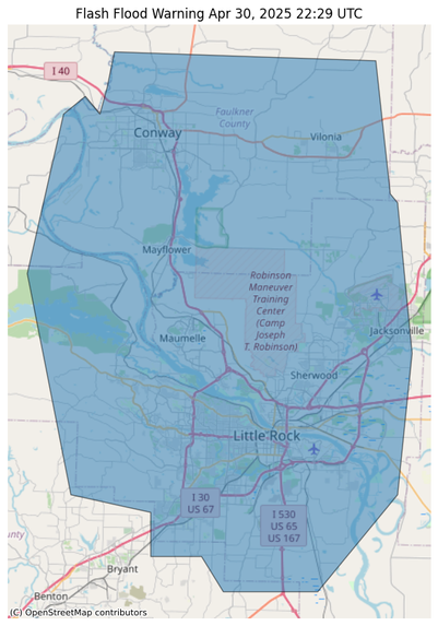
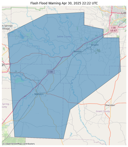
#NWS #flood #nwsflashflood #FlashFloodWarning Flash Flood Warning for Faulkner, AR; Perry, AR; Pulaski, AR; Saline, AR #ARwx https://alerts-v2.weather.gov/search?id=urn:oid:2.49.0.1.840.0.59dac93d58e517fa371ef0d1cc1edcb5c5b8320a.001.1
#NWS #flood #nwsflashflood #FlashFloodWarning Flash Flood Warning for Garland, AR; Grant, AR; Hot Spring, AR; Saline, AR #ARwx https://alerts-v2.weather.gov/search?id=urn:oid:2.49.0.1.840.0.77761cc1a2b8f8bc83851deb135f5bcd1656e446.001.1
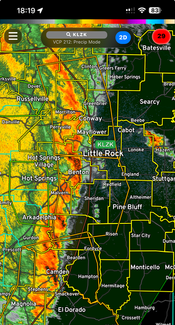
6:19 pm Screen Shot of Radar Omega picture of radar KLZX Little Rock showing strong line of storms ENE.
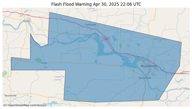
#NWS #flood #nwsflashflood #FlashFloodWarning Flash Flood Warning for Johnson, AR; Logan, AR; Pope, AR; Yell, AR #ARwx https://alerts-v2.weather.gov/search?id=urn:oid:2.49.0.1.840.0.0b9c98b506b708a4c6361042df5d177f64af9641.001.1
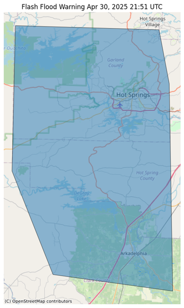
#NWS #flood #nwsflashflood #FlashFloodWarning Flash Flood Warning for Clark, AR; Garland, AR; Hot Spring, AR #ARwx https://alerts-v2.weather.gov/search?id=urn:oid:2.49.0.1.840.0.cf096ba5d2e13961d241a6dc0eebab2510f7e957.001.1
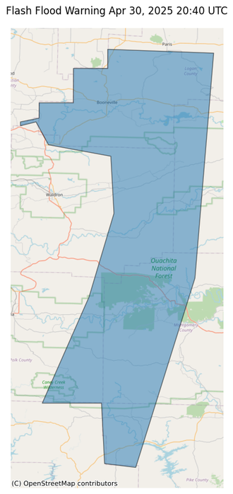
#NWS #flood #nwsflashflood #FlashFloodWarning Flash Flood Warning for Logan, AR; Montgomery, AR; Pike, AR; Polk, AR; Scott, AR; Yell, AR #ARwx https://alerts-v2.weather.gov/search?id=urn:oid:2.49.0.1.840.0.89fe97c4323b8209fee2ac1c9749fb27cd0e9e92.001.1
#SevereWeather #ARwx #LAwx #TXwx
URGENT - IMMEDIATE BROADCAST REQUESTED
Tornado Watch Number 198
NWS Storm Prediction Center Norman OK
105 PM CDT Wed Apr 30 2025
The NWS Storm Prediction Center has issued a
* Tornado Watch for portions of
Southwest Arkansas
Northwest Louisiana
East Central Texas
* Effective this Wednesday afternoon and evening from 105 PM until 800 PM CDT.
* Primary threats include...
A few tornadoes likely with a couple intense tornadoes possible
Scattered damaging wind gusts to 70 mph likely
Scattered large hail and isolated very large hail events to 2 inches in diameter possible
SUMMARY...Thunderstorms are expected to rapidly develop across the watch area through the afternoon. Sufficient vertical shear and instability will pose a risk for a few tornadoes, along with large hail and damaging wind gusts.
The tornado watch area is approximately along and 70 statute miles north and south of a line from 40 miles south southwest of Waco TX to 50 miles east of Shreveport LA. For a complete depiction of the watch see the associated watch outline update (WOUS64 KWNS WOU8).
URGENT - IMMEDIATE BROADCAST REQUESTED
Tornado Watch Number 199
NWS Storm Prediction Center Norman OK
325 PM CDT Wed Apr 30 2025
The NWS Storm Prediction Center has issued a
* Tornado Watch for portions of Central Arkansas
* Effective this Wednesday afternoon and evening from 325 PM until 1000 PM CDT.
* Primary threats include...
A couple tornadoes possible
Scattered damaging wind gusts to 70 mph possible
Isolated large hail events to 1.5 inches in diameter possible
SUMMARY...A line of strong/severe thunderstorms over western Arkansas will progress eastward through the late afternoon and evening. Locally damaging wind gusts and a few tornadoes will be possible with this activity.
The tornado watch area is approximately along and 70 statute miles east and west of a line from 50 miles northeast of Russellville AR to 40 miles west southwest of Monticello AR. For a complete depiction of the watch see the associated watch outline update
(WOUS64 KWNS WOU9).
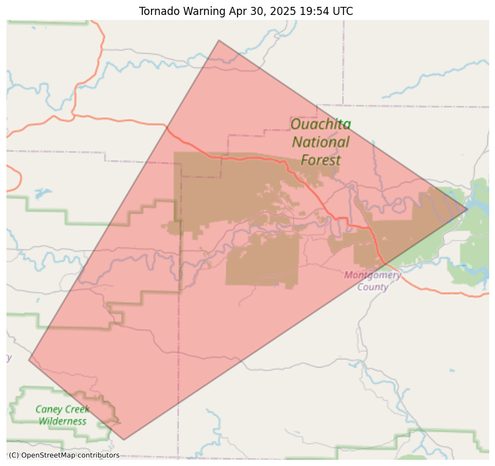
#NWS #tornado Tornado Warning for Montgomery, AR; Polk, AR; Scott, AR #ARwx https://alerts-v2.weather.gov/search?id=urn:oid:2.49.0.1.840.0.1faba962dc1f490c3654dfe169915513331188be.001.1
@easwatch #SevereWeather #ARwx #EAS #WEA for #Montgomery, #AR; #Polk, #AR; #Scott, #AR: National Weather Service: #TORNADO WARNING in this area until 3:45 PM CDT. Take shelter now in a basement or an interior room on the lowest floor of a sturdy building. If you are outdoors, in a mobile home, or in a vehicle, move to the closest substantial shelter and protect yourself from flying debris. Check media. Source: NWS Little Rock AR ** DO NOT RELY ON THIS FEED FOR LIFE SAFETY, SEEK OUT OFFICIAL SOURCES ***
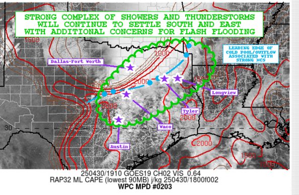
Mesoscale Precipitation Discussion 0203
NWS WOC College Park MD
325 PM EDT Wed Apr 30 2025
Areas affected...Central to NE TX...Far SW AR...Far
NW LA
Concerning...Heavy rainfall...Flash flooding likely
SUMMARY...A complex of heavy showers and thunderstorms will continue to gradually settle south and east going through the afternoon and early evening hours. Intense rainfall rates and storm totals will likely promote additional areas of flash flooding which will include locally considerable/significant urban flash flooding impacts.
DISCUSSION...The afternoon GOES-E visible satellite imagery shows a substantial amount of CU/TCU development across central to northeast TX out ahead of a well-defined and long-lived MCS that has been transiting northern TX and eastern OK over the last several hours. The warm-sector airmass with the aid of strong diurnal heating and a moisture-laden boundary layer with surface dewpoints in the upper 60s to low 70s is affording MLCAPE values as high as 1500 to 3000 J/kg. This includes the Austin to Waco corridor on northeastward up into the Tyler and Longview vicinity...


